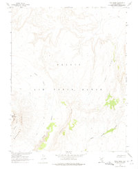
1962 Map of Trail Ridge
USGS Topo · Published 1975About this map
Nellis Air Force Range dominates this 1962 landscape in Nye County, Nevada, presenting a high-altitude desert environment defined by stark geological formations. The topography is anchored by the prominent Trail Ridge and the heights of Black Mountain to the west. This area, mapped in cooperation with the Atomic Energy Commission, reflects the mid-century military and scientific utility of the Nevada desert. Sharp vertical relief is detailed through features like Ribbon Cliff, Hidden Cliff, and the narrow drainage of Thirsty Canyon. A series of Jeep Trails provide the only visible infrastructure across the Boulder Cuesta, illustrating the extreme isolation and specialized use of the territory during the Cold War era. Small pockets of vegetation are noted along the lower reaches of Thirsty and its eastern branches, providing a rare contrast to the surrounding stone.
Find a feature on this map
11 named features on this map. Tap any name to fly to it.
Don’t see what you’re looking for? This feature index may not catch every label — zoom into the map to look around manually.
Map Details
Editions of this 1962 Trail Ridge Map
2 editions found
Other maps of this area

1908 · Kawich
USGS Topo · 1:250,000

1942 · Tolicha Peak
USGS Topo · 1:125,000

1942 · Wheelbarrow Peak
USGS Topo · 1:125,000

1952 · Timber Mountain
USGS Topo · 1:62,500

1952 · Silent Canyon
USGS Topo · 1:62,500
1952 · Black Mtn
USGS Topo · 1:62,500

1954 · Goldfield
USGS Topo · 1:250,000

1955 · Goldfield
USGS Topo · 1:250,000

1958 · Goldfield
USGS Topo · 1:250,000
1961 · Scrugham Peak
USGS Topo · 1:24,000