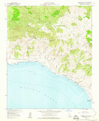
1959 Map of Tranquillon Mountain
USGS Topo · Published 1960About this map
The U S Naval Missile Facility occupies the northern reaches of this coastal landscape, situated along the rugged Santa Barbara shoreline where the Santa Ynez Mountains meet the sea. This 1950s survey documents a critical transition in land use, as the expansive Sudden Flats and various traditional ranching areas were increasingly defined by federal defense infrastructure. The coastline is marked by significant landmarks including Point Arguello and Punta de la Concepcion, which have long served as navigational anchors for Pacific maritime traffic.
Find a feature on this map
46 named features on this map. Tap any name to fly to it.
Don’t see what you’re looking for? This feature index may not catch every label — zoom into the map to look around manually.
Map Details
Editions of this 1959 Tranquillon Mountain Map
3 editions found
Other maps of this area

1905 · Guadalupe
USGS Topo · 1:125,000

1905 · Lompoc
USGS Topo · 1:125,000

1942 · Point Arguello
USGS Topo · 1:62,500

1942 · Guadalupe
USGS Topo · 1:125,000

1942 · Lompoc
USGS Topo · 1:125,000

1942 · Lompoc
USGS Topo · 1:62,500

1942 · Pt. Conception
USGS Topo · 1:62,500

1943 · Lompoc
USGS Topo · 1:125,000

1947 · Lompoc
USGS Topo · 1:24,000

1947 · Surf
USGS Topo · 1:24,000