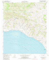
1959 Map of Tranquillon Mtn
USGS Topo · Published 1987About this map
The U S Naval Missile Facility dominates the northern reaches of this coastal survey, where the rugged Tranquillon Mountains meet the edge of the Pacific Ocean. Along the shoreline, the Southern Pacific railroad tracks trace the narrow coastal shelf below high bluffs, passing through the small settlement of Sudden. The landscape is defined by deep coastal canyons, including Cañada Honda Creek and La Honda Canyon, which drain the steep interior toward the rocky headlands of Punta De La Concepcion. Inland, the topography rises sharply to Tranquillon Mtn and Wild Horse Peak, marked by a network of jeep trails and remote gaging stations. This area represents a unique intersection of mid-century military expansion and the traditional ranching geography of the Gaviota Coast, preserved here just before the era of intensive space-launch operations at the neighboring base.
Find a feature on this map
52 named features on this map. Tap any name to fly to it.
Don’t see what you’re looking for? This feature index may not catch every label — zoom into the map to look around manually.
Map Details
Editions of this 1959 Tranquillon Mtn Map
3 editions found
Other maps of this area

1905 · Guadalupe
USGS Topo · 1:125,000

1905 · Lompoc
USGS Topo · 1:125,000

1942 · Point Arguello
USGS Topo · 1:62,500

1942 · Guadalupe
USGS Topo · 1:125,000

1942 · Lompoc
USGS Topo · 1:125,000

1942 · Lompoc
USGS Topo · 1:62,500

1942 · Pt. Conception
USGS Topo · 1:62,500

1943 · Lompoc
USGS Topo · 1:125,000

1947 · Lompoc
USGS Topo · 1:24,000

1947 · Surf
USGS Topo · 1:24,000