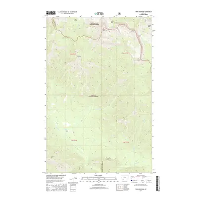
2017 Map of Trap Mountain
USGS Topo · Published 2017About this map
Lewis and Clark Range dominates the eastern boundary of this high-elevation landscape, where the continental divide legacy is felt along the border of Lewis & Clark National Forest and Flathead National Forest. This 2017 survey details a wilderness of drainage basins and peaks, including the prominent Trap Mtn and Scarlet Mtn. The terrain is defined by its dramatic vertical relief, with Camp Creek Pass providing a critical high-altitude transition point. Water flows away from these summits via systems like Danaher Cr and Lost Fork Ahorn Cr, carving through distinct basins such as Pearl Basin and Ahorn Basin. The area’s complex topography is further highlighted by features like Hoadley Reef and Woodtick Mtn, illustrating a landscape managed for conservation and wilderness preservation.
Find a feature on this map
27 named features on this map. Tap any name to fly to it.
Don’t see what you’re looking for? This feature index may not catch every label — zoom into the map to look around manually.
Map Details
Editions of this 2017 Trap Mountain Map
This is the sole edition of this map. No revisions or reprints were ever made.
Other maps of this area

1902 · Ovando
USGS Topo · 1:125,000

1903 · Saypo
USGS Topo · 1:125,000

1903 · Coopers Lake
USGS Topo · 1:125,000

1905 · Ovando
USGS Topo · 1:125,000

1936 · Silvertip
USGS Topo · 1:96,000

1942 · Silvertip
USGS Topo · 1:125,000

1955 · Choteau
USGS Topo · 1:250,000

1957 · Choteau
USGS Topo · 1:250,000

1958 · Choteau
USGS Topo · 1:250,000

1958 · Pretty Prairie
USGS Topo · 1:24,000