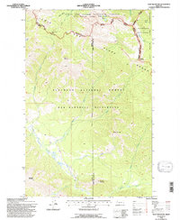
1994 Map of Trap Mountain
USGS Topo · Published 1997About this map
The Lewis and Clark Range dominates this mid-1990s survey, representing a high-altitude wilderness where the Continental Divide separates the Lewis and Clark National Forest from the Flathead National Forest. This remote landscape is defined by its lack of modern infrastructure, centered instead on the intersection of the Bob Marshall Wilderness and Scapegoat Wilderness. The mapping reveals a complex network of glacial basins and peaks, including Trap Mountain, Scarlet Mountain, and Ayres Peak. The presence of the Basin Creek Cabin and the Continental Divide Trail indicates the primitive nature of human travel through the area. Waterways like Danaher Creek and the Sun River drain the high slopes, while prominent geological features like Hoadley Reef and Sentinel Mountain provide navigation landmarks for those traversing the backcountry through Camp Creek Pass.
Find a feature on this map
43 named features on this map. Tap any name to fly to it.
Don’t see what you’re looking for? This feature index may not catch every label — zoom into the map to look around manually.
Map Details
Editions of this 1994 Trap Mountain Map
This is the sole edition of this map. No revisions or reprints were ever made.
Other maps of this area

1902 · Ovando
USGS Topo · 1:125,000

1903 · Saypo
USGS Topo · 1:125,000

1903 · Coopers Lake
USGS Topo · 1:125,000

1905 · Ovando
USGS Topo · 1:125,000

1936 · Silvertip
USGS Topo · 1:96,000

1942 · Silvertip
USGS Topo · 1:125,000

1955 · Choteau
USGS Topo · 1:250,000

1957 · Choteau
USGS Topo · 1:250,000

1958 · Choteau
USGS Topo · 1:250,000

1958 · Pretty Prairie
USGS Topo · 1:24,000