1979 Map of Trenholm
USGS Topo · Published 1982About this map
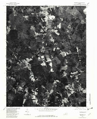
Trenholm serves as a central junction in this rural Powhatan County landscape, where small clearings and agricultural fields dot the heavily forested Virginia countryside. Produced by the U.S. Geological Survey in cooperation with the Soil Conservation Service, this orthophotoquad utilizes 1979 aerial imagery to provide a photographic perspective of the region's land use and hydrology during the late twentieth century. To the south and east, the small communities of Ballsville and Belona anchor the local road network, while the terrain is defined by the winding paths of Muddy Creek and Deep Creek. The imagery reveals the varied water bodies of the area, including Redford Pond and the Powhatan Lakes, offering researchers a clear view of the timber and farming patterns that shaped this portion of Virginia before modern development.
Find a feature on this map
7 named features on this map. Tap any name to fly to it.
Don’t see what you’re looking for? This feature index may not catch every label — zoom into the map to look around manually.
Map Details
Editions of this 1979 Trenholm Map
This is the sole edition of this map. No revisions or reprints were ever made.
Other maps of this area

1890 · Goochland
USGS Topo · 1:125,000

1891 · Palmyra
USGS Topo · 1:125,000

1891 · Farmville
USGS Topo · 1:125,000

1892 · Goochland
USGS Topo · 1:125,000

1893 · Farmville
USGS Topo · 1:125,000

1895 · Palmyra
USGS Topo · 1:125,000

1897 · Amelia
USGS Topo · 1:125,000

1897 · Palmyra
USGS Topo · 1:125,000

1943 · Goochland
USGS Topo · 1:31,680

1943 · Powhatan
USGS Topo · 1:31,680