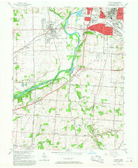
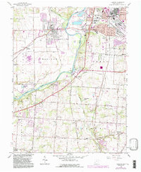
1966 Map of Trenton
USGS Topo · Published 1968About this map
The Great Miami River bisects this landscape, flowing past a dense network of industrial and transport corridors during the mid-1960s. The bustling eastern edge includes Middletown and the residential expansion of Oneida and Mayfield, while the west remains largely defined by the agricultural fields of Madison and Wayne townships. Heavy rail infrastructure is prominent, with the Baltimore and Ohio, Pennsylvania, and New York Central railroads converging to serve the region's manufacturing heart. Local community life is evidenced by numerous landmarks, from the Amanda Ch and Amanda Jr High Sch to several historic burial grounds including Miltonville Cem and Spring Hill Cem. Significant recreational and conservation spaces like the Rentschler Forest Preserve and a YMCA Camp line the river, offering a stark contrast to the nearby Gravel Pits and industrial zones.
Find a feature on this map
87 named features on this map. Tap any name to fly to it.
Don’t see what you’re looking for? This feature index may not catch every label — zoom into the map to look around manually.
Map Details
Editions of this 1966 Trenton Map
5 editions found
Other maps of this area

1904 · Mason
USGS Topo · 1:62,500

1906 · Mason
USGS Topo · 1:62,500

1908 · Miamisburg
USGS Topo · 1:62,500

1911 · Oxford
USGS Topo · 1:62,500

1915 · Hamilton
USGS Topo · 1:62,500

1917 · Hamilton
USGS Topo · 1:62,500

1951 · Franklin
USGS Topo · 1:24,000

1953 · Cincinnati
USGS Topo · 1:250,000

1955 · Monroe
USGS Topo · 1:24,000

1955 · Hamilton
USGS Topo · 1:24,000