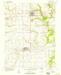
1957 Map of Trenton
USGS Topo · Published 1958About this map
The boundary between St Clair and Clinton counties bisects this 1957 survey, where the agricultural landscape is defined by the parallel paths of two major railroads. The Baltimore and Ohio line serves the northern settlements, passing directly through Trenton and near Summerfield, while the Southern railroad provides the primary transit artery for New Baden to the south. These rail corridors influenced the placement of early community infrastructure, including the Sewage Disposal plant near New Baden and several rural burial grounds like Wittmer Cem and St Marys Cem.
Find a feature on this map
35 named features on this map. Tap any name to fly to it.
Don’t see what you’re looking for? This feature index may not catch every label — zoom into the map to look around manually.
Map Details
Editions of this 1957 Trenton Map
2 editions found
Other maps of this area

1906 · Breese
USGS Topo · 1:62,500

1907 · Breese
USGS Topo · 1:62,500

1907 · Belleville
USGS Topo · 1:62,500

1910 · Okawville
USGS Topo · 1:62,500

1912 · New Athens
USGS Topo · 1:62,500

1935 · Lebanon
USGS Topo · 1:24,000

1940 · Okawville
USGS Topo · 1:62,500

1949 · Lebanon
USGS Topo · 1:24,000

1949 · St. Jacob
USGS Topo · 1:24,000
1954 · Lebanon
USGS Topo · 1:24,000