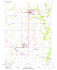
1957 Map of Trenton
USGS Topo · Published 1981About this map
Trenton and New Baden anchor this mid-century landscape straddling the line between St. Clair and Clinton Counties. The agricultural character of the region is defined by the drainage of Sugar Creek and the southern flow of Lake Br, with the terrain marked by family-named landmarks like Rayhill and Reinhardt. Transportation corridors are prominent, with the Baltimore and Ohio railroad serving the northern settlements and the Southern line passing through the south.
Find a feature on this map
24 named features on this map. Tap any name to fly to it.
Don’t see what you’re looking for? This feature index may not catch every label — zoom into the map to look around manually.
Map Details
Editions of this 1957 Trenton Map
2 editions found
Other maps of this area

1906 · Breese
USGS Topo · 1:62,500

1907 · Breese
USGS Topo · 1:62,500

1907 · Belleville
USGS Topo · 1:62,500

1910 · Okawville
USGS Topo · 1:62,500

1912 · New Athens
USGS Topo · 1:62,500

1935 · Lebanon
USGS Topo · 1:24,000

1940 · Okawville
USGS Topo · 1:62,500

1949 · Lebanon
USGS Topo · 1:24,000

1949 · St. Jacob
USGS Topo · 1:24,000
1954 · Lebanon
USGS Topo · 1:24,000