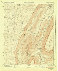
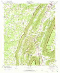
1946 Map of Trenton
USGS Topo · Published 1947About this map
Trenton serves as a focal point in this 1946 survey, situated where Town Creek and the Southern railroad line run through the valley between the towering plateaus of Lookout Mountain and Sand Mountain. The terrain is defined by steep ridges and deep recesses like Deer Head Cove and Johnson Crook, creating a landscape where settlements and travel are dictated by gaps and gulches. Significant rural infrastructure is evident in the numerous family-named burial grounds, including Countess Cem, Newman Cem, and Easley Cem, which offer specific locations for genealogical research. Further south, Rising Fawn sits along the rail line, while smaller communities like Stewart Town and Floral Crest occupy the higher elevations. The network of roads, such as Brow Road and Stewart Town Road, connects the dispersed mountain churches like Mt Olive Ch and Byrds Chapel to the valley floor.
Find a feature on this map
62 named features on this map. Tap any name to fly to it.
Don’t see what you’re looking for? This feature index may not catch every label — zoom into the map to look around manually.
Map Details
Editions of this 1946 Trenton Map
5 editions found
Other maps of this area

1886 · Ringgold
USGS Topo · 1:125,000

1886 · Stevenson
USGS Topo · 1:125,000

1892 · Ringgold
USGS Topo · 1:125,000

1892 · Stevenson
USGS Topo · 1:125,000

1895 · Stevenson
USGS Topo · 1:125,000

1935 · Durham
USGS Topo · 1:24,000

1936 · Trenton
USGS Topo · 1:24,000

1936 · Ider
USGS Topo · 1:24,000

1936 · Shellmound
USGS Topo · 1:24,000

1936 · Bridgeport
USGS Topo · 1:24,000