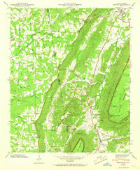
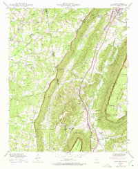
1946 Map of Trenton
USGS Topo · Published 1967About this map
Lookout Mountain dominates the landscape of this 1946 survey, marking the dramatic topography along the Georgia and Alabama border. The Southern RR corridor serves as the primary artery for the valley settlements, connecting the town of Trenton to Rising Fawn and smaller rural communities. The map captures a detailed snapshot of mountain life before modern development, where small settlements like Floral Crest and Higdon sit atop the plateau alongside family-named landmarks like Deer Head Cove. Numerous country churches and burial grounds, such as Byrds Chapel, Shiloh Ch, and the Countess Cem, are scattered throughout the hills, providing a clear view of the mid-century social and genealogical geography in this corner of Dade County.
Find a feature on this map
61 named features on this map. Tap any name to fly to it.
Don’t see what you’re looking for? This feature index may not catch every label — zoom into the map to look around manually.
Map Details
Editions of this 1946 Trenton Map
5 editions found
Other maps of this area

1886 · Ringgold
USGS Topo · 1:125,000

1886 · Stevenson
USGS Topo · 1:125,000

1892 · Ringgold
USGS Topo · 1:125,000

1892 · Stevenson
USGS Topo · 1:125,000

1895 · Stevenson
USGS Topo · 1:125,000

1935 · Durham
USGS Topo · 1:24,000

1936 · Trenton
USGS Topo · 1:24,000

1936 · Ider
USGS Topo · 1:24,000

1936 · Shellmound
USGS Topo · 1:24,000

1936 · Bridgeport
USGS Topo · 1:24,000