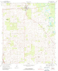
1968 Map of Trenton
USGS Topo · Published 1990About this map
The town of Trenton serves as a focal point in this late 1960s survey, situated at the junction where the Seaboard Coast Line railroad meets local roads in northern Florida. The landscape is defined by the transition between Gilchrist and Levy Counties, marked by numerous karst depressions and water bodies such as Raulison Pond and Spring Pond. Local education and community life are grounded in landmarks like the John Morse High Sch and the County Training School For Boys, providing valuable spatial context for mid-century genealogy. To the southeast, rural crossroads are anchored by the Shady Grove Ch and its adjacent Shady Grove Cem, while the southern edge of the map begins to capture the outskirts of Chiefland. This topographic record highlights the scattered settlement patterns typical of the region before significant modern development altered the rural character of these pine and wetland environments.
Find a feature on this map
16 named features on this map. Tap any name to fly to it.
Don’t see what you’re looking for? This feature index may not catch every label — zoom into the map to look around manually.
Map Details
Editions of this 1968 Trenton Map
3 editions found
Other maps of this area

1954 · Chiefland
USGS Topo · 1:24,000

1954 · Bronson
USGS Topo · 1:24,000

1954 · Manatee Springs
USGS Topo · 1:24,000

1954 · Gainesville
USGS Topo · 1:250,000

1958 · Gainesville
USGS Topo · 1:250,000

1959 · Gainesville
USGS Topo · 1:250,000

1968 · Newberry SW
USGS Topo · 1:24,000

1968 · Waters Lake
USGS Topo · 1:24,000

1968 · Fourmile Lake
USGS Topo · 1:24,000

1968 · Trenton
USGS Topo · 1:24,000