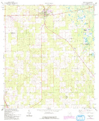
1968 Map of Trenton
USGS Topo · Published 1993About this map
Trenton serves as the focal point of this North Florida survey, situated at a cross-section of Gilchrist County’s agricultural and institutional landscape. The map highlights key educational and community centers of the late 1960s, such as John Morse High Sch and the County Training School For Boys. To the south, the boundary between Gilchrist Co and Levy Co cuts across a terrain dotted with small water bodies like Spring Pond and Raulison Pond. This 1968 study, later updated with 1989 aerial revisions, preserves the location of rural congregations and burial grounds, including the Pine Grove Ch and adjacent Pine Grove Cem. The presence of a Landing Field and multiple Quarry sites near Chiefland reflects the local industry and transportation infrastructure of the era, while the small settlement of Haven Winquipin remains a distinct marker on the eastern edge of the quadrangle.
Find a feature on this map
16 named features on this map. Tap any name to fly to it.
Don’t see what you’re looking for? This feature index may not catch every label — zoom into the map to look around manually.
Map Details
Editions of this 1968 Trenton Map
3 editions found
Other maps of this area

1954 · Chiefland
USGS Topo · 1:24,000

1954 · Bronson
USGS Topo · 1:24,000

1954 · Manatee Springs
USGS Topo · 1:24,000

1954 · Gainesville
USGS Topo · 1:250,000

1958 · Gainesville
USGS Topo · 1:250,000

1959 · Gainesville
USGS Topo · 1:250,000

1968 · Newberry SW
USGS Topo · 1:24,000

1968 · Waters Lake
USGS Topo · 1:24,000

1968 · Fourmile Lake
USGS Topo · 1:24,000

1968 · Trenton
USGS Topo · 1:24,000