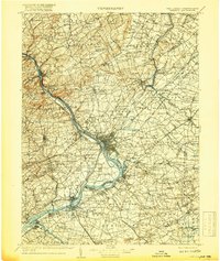
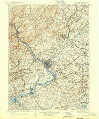
1907 Map of Trenton
USGS Topo · Published 1907About this map
Trenton and its industrial corridor dominate the central bend of the Delaware River at the dawn of the twentieth century, serving as a pivot point between the river's upper reaches and the tidal waters to the south. This era is defined by an intricate network of competing transportation systems, where the Delaware and Raritan Canal and the Pennsylvania Canal still parallel the water's edge alongside a dense web of rail lines, including the Pennsylvania RR and the Belvidere Delaware RR. The landscape transitions from the rising elevations of Sourland Mountain and Rocky Hill in the north to the fertile plains of Burlington County.
Find a feature on this map
288 named features on this map. Tap any name to fly to it.
Don’t see what you’re looking for? This feature index may not catch every label — zoom into the map to look around manually.
Map Details
Editions of this 1907 Trenton Map
4 editions found