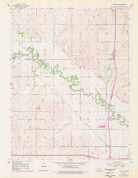
1955 Map of Trenton
USGS Topo · Published 1978About this map
The Saline River winds in tight, serpentine oxbows across this Kansas landscape, crossing the border between Ottawa and Saline counties. Small rural hubs and whistle-stops such as Marydel, Shipton, and Trenton anchor the agricultural territory, connected by the diagonal route of the Union Pacific railroad. The map provides a clear look at mid-century community infrastructure, from the Lockard Sch to the scattered burial grounds of Walnut Hill Cem, Crown Point Cem, and Shiloh Cem. These features, along with the distinct boundaries of Culver, Bennington, and Pleasant Valley townships, reflect a sparsely populated but well-organized prairie economy. Land use is further evidenced by a Gravel Pit near the river and the presence of Wary Lake, situated just north of the county line.
Find a feature on this map
16 named features on this map. Tap any name to fly to it.
Don’t see what you’re looking for? This feature index may not catch every label — zoom into the map to look around manually.
Map Details
Editions of this 1955 Trenton Map
2 editions found
Other maps of this area

1892 · Salina
USGS Topo · 1:125,000

1892 · Minneapolis
USGS Topo · 1:125,000

1942 · Salina
USGS Topo · 1:125,000

1955 · Salina
USGS Topo · 1:24,000

1955 · Salina SW
USGS Topo · 1:24,000

1955 · Trenton
USGS Topo · 1:24,000

1955 · Brookville
USGS Topo · 1:24,000

1955 · Culver
USGS Topo · 1:24,000

1955 · New Cambria
USGS Topo · 1:24,000

1955 · Manhattan
USGS Topo · 1:250,000