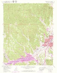
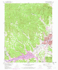
1951 Map of Trinidad West
USGS Topo · Published 1979About this map
Coal mining and rail commerce define the industrial landscape south of Trinidad in this detailed look at the 1950s. The concentration of mining activity is evident in the cluster of shafts and pits near Cokedale, including the Main Cokedale Mine and the East Cokedale Mine, while the southern reaches near Starkville feature the Starkville No 1 Coal Mine and Mc Laughlin Mine. These extraction sites were served by the heavy rail corridors of the Atchison Topeka and Santa Fe and the Colorado and Wyoming railroads, which parallel the Purgatoire River. The map also captures the local social fabric of Las Animas County, from higher education at Trinidad State Jr College to the religious centers of Sacred Heart Church and St Josephs Church. Topographical landmarks like Simpsons Rest and the vast Picketwire Lake provide a clear sense of the rugged local geography surrounding the urban core of Trinidad and the nearby settlement of Jansen.
Find a feature on this map
57 named features on this map. Tap any name to fly to it.
Don’t see what you’re looking for? This feature index may not catch every label — zoom into the map to look around manually.
Map Details
Editions of this 1951 Trinidad West Map
6 editions found
Other maps of this area

1891 · Spanish Peaks
USGS Topo · 1:125,000

1892 · Elmoro
USGS Topo · 1:125,000

1893 · Spanish Peaks
USGS Topo · 1:125,000

1893 · Elmoro
USGS Topo · 1:125,000

1895 · Spanish Peaks
USGS Topo · 1:125,000

1897 · Elmoro
USGS Topo · 1:125,000

1897 · Spanish Peaks
USGS Topo · 1:125,000

1900 · Spanish Peaks
USGS Topo · 1:125,000

1951 · Trinidad
USGS Topo · 1:24,000

1951 · Valdez
USGS Topo · 1:24,000