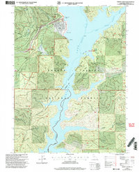
1998 Map of Trinity Center
USGS Topo · Published 2003About this map
Trinity Center sits at the edge of the Lake Trinity reservoir in this late-twentieth-century landscape, where the rising waters of the East Fork Trinity River have transformed the mountain valley. The settlement is supported by infrastructure like the Trinity Center Marina, a local Airport, and a Boat Ramp, while the surrounding terrain is marked by steep ridges and deep gulches. Evidence of resource extraction remains visible in the form of a Hydraulic Mine near Swift Creek and a Gravel Pit to the north.
Find a feature on this map
107 named features on this map. Tap any name to fly to it.
Don’t see what you’re looking for? This feature index may not catch every label — zoom into the map to look around manually.
Map Details
Editions of this 1998 Trinity Center Map
2 editions found
Other maps of this area

1886 · Shasta
USGS Topo · 1:250,000

1890 · Red Bluff
USGS Topo · 1:250,000

1894 · Red Bluff
USGS Topo · 1:250,000

1894 · Shasta
USGS Topo · 1:250,000

1913 · Weaverville
USGS Topo · 1:125,000

1923 · Sawyers Bar
USGS Topo · 1:125,000

1931 · Etna
USGS Topo · 1:96,000

1934 · Etna
USGS Topo · 1:125,000

1948 · Weed
USGS Topo · 1:250,000

1950 · Weed
USGS Topo · 1:250,000