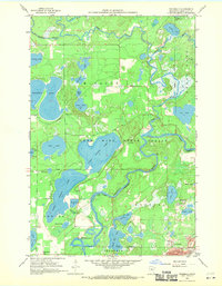
1959 Map of Trommald
USGS Topo · Published 1970About this map
The Mississippi River and Pine River converge in a complex wetland landscape of the Crow Wing State Forest, where the iron-rich geology of the Cuyuna Range begins to influence the terrain. This 1959 survey, published in cooperation with the Iron Range Resources and Rehabilitation Commission, highlights the transition from recreation and timber to industrial mining. The settlement of Trommald sits at the southern edge, defined by adjacent operations such as the Maroco Mine and Musser Mine.
Find a feature on this map
40 named features on this map. Tap any name to fly to it.
Don’t see what you’re looking for? This feature index may not catch every label — zoom into the map to look around manually.
Map Details
Editions of this 1959 Trommald Map
3 editions found

Other maps of this area

1912 · Deerwood
USGS Topo · 1:62,500

1913 · Cuyuna
USGS Topo · 1:62,500

1914 · Deerwood
USGS Topo · 1:62,500

1915 · Cuyuna
USGS Topo · 1:62,500

1915 · Brainerd
USGS Topo · 1:62,500

1918 · Brainerd
USGS Topo · 1:62,500

1953 · Duluth
USGS Topo · 1:250,000

1953 · Brainerd
USGS Topo · 1:250,000

1957 · Brainerd
USGS Topo · 1:250,000

1958 · Brainerd
USGS Topo · 1:250,000