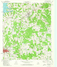
1973 Map of Troup East
USGS Topo · Published 1976About this map
The Good Omen Oil Field dominates the central landscape of this East Texas survey, where oil and gas wells are interspersed among the rolling woodlands and small agricultural clearings. The northern portion is defined by the reaching fingers of Lake Tyler East, including Swinney Road Bay and North Bridge Cove, which shape the Twin Bay Peninsula. This era represents a period of established industrial extraction and rural community life, where the Missouri Pacific railroad serves the larger settlement of Troup, while smaller hubs like Arp and Sinclair City anchor the surrounding countryside. Deeply rooted local history is visible in the network of country churches and family burial grounds, such as Mt Herman Ch, Ebenezer Cem, and Shiloh Cem. The presence of the Hilltop Country Club and Rodeo Ground near the Smith and Cherokee county line reflects the social character of the region during the early 1970s.
Find a feature on this map
57 named features on this map. Tap any name to fly to it.
Don’t see what you’re looking for? This feature index may not catch every label — zoom into the map to look around manually.
Map Details
Editions of this 1973 Troup East Map
This is the sole edition of this map. No revisions or reprints were ever made.
Other maps of this area

1935 · Henderson
USGS Topo · 1:48,000

1936 · Kilgore
USGS Topo · 1:48,000

1937 · Troupe
USGS Topo · 1:48,000

1938 · Winona
USGS Topo · 1:48,000

1939 · Henderson
USGS Topo · 1:62,500

1940 · Kilgore
USGS Topo · 1:62,500

1943 · Troup
USGS Topo · 1:62,500

1943 · Winona
USGS Topo · 1:62,500

1956 · Tyler
USGS Topo · 1:250,000

1966 · Hope Pond
USGS Topo · 1:24,000