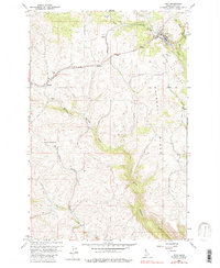
1960 Map of Troy
USGS Topo · Published 1982About this map
Troy serves as the primary hub in this 1960 survey of Latah County, Idaho, situated where the Northern Pacific railroad winds through the Palouse hills. The landscape is defined by elevated terrain such as American Ridge and Driscoll Ridge, which overlook the deeply incised drainages of Middle Potlatch Creek and the West Fork Little Bear Creek. Small railroad-adjacent settlements like Howell, Joel, and Cornwall provide a view into the mid-century rural infrastructure of the region, supported by landmarks like the Aspendale Community Hall. The map reveals the intricate relationship between the rail corridor and the plateau topography, showing various Gravel Pits and geographic features like Dutch Flat that shaped local industry and transit during this era.
Find a feature on this map
16 named features on this map. Tap any name to fly to it.
Don’t see what you’re looking for? This feature index may not catch every label — zoom into the map to look around manually.
Map Details
Editions of this 1960 Troy Map
2 editions found
Other maps of this area

1955 · Pullman
USGS Topo · 1:250,000

1958 · Pullman
USGS Topo · 1:250,000

1960 · Troy
USGS Topo · 1:24,000

1960 · Robinson Lake
USGS Topo · 1:24,000

1960 · Moscow Mtn
USGS Topo · 1:24,000

1960 · Moscow East
USGS Topo · 1:24,000

1960 · Potlatch
USGS Topo · 1:62,500

1961 · Deary
USGS Topo · 1:62,500

1961 · Kendrick
USGS Topo · 1:62,500

1961 · Moscow
USGS Topo · 1:62,500