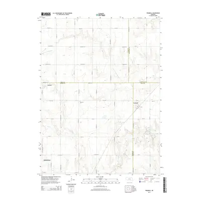
2014 Map of Trumbull
USGS Topo · Published 2014About this map
Trumbull and the surrounding agricultural plains are defined by the convergence of four counties: Adams, Clay, Hall, and Hamilton. This 2014 survey documents the landscape as it transitions from the outskirts of Hastings toward the smaller rail-influenced settlements of Hansen and Trumbull. The drainage of the W Fork Big Blue River and its northern branch, along with Beaver Cr and Flat Cr, shapes the local topography, which is largely organized around an efficient grid of section roads like Rosedale Rd E and Rainforth Rd W. Local history is anchored by landmarks such as the Greenwood Cem and the Arnold Reservoir 1 southeast of Trumbull. The inclusion of the NE-1D-Spur reflects the modern highway infrastructure serving this productive corner of the Nebraska plains.
Find a feature on this map
34 named features on this map. Tap any name to fly to it.
Don’t see what you’re looking for? This feature index may not catch every label — zoom into the map to look around manually.
Map Details
Editions of this 2014 Trumbull Map
This is the sole edition of this map. No revisions or reprints were ever made.
Other maps of this area

1892 · Grand Island
USGS Topo · 1:62,500

1895 · Grand Island
USGS Topo · 1:62,500

1898 · Grand Island
USGS Topo · 1:125,000

1955 · Grand Island
USGS Topo · 1:250,000

1957 · Grand Island
USGS Topo · 1:250,000

1958 · Grand Island
USGS Topo · 1:250,000
1962 · Doniphan
USGS Topo · 1:24,000
1962 · Alda
USGS Topo · 1:24,000
1967 · Giltner
USGS Topo · 1:24,000

1969 · Hastings East
USGS Topo · 1:24,000