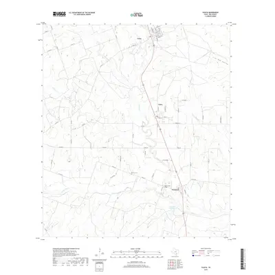
2019 Map of Tuleta
USGS Topo · Published 2019About this map
Pettus, Tuleta, and Normanna form a linear settlement pattern along the modern highway corridor in Bee County, reflecting a landscape defined by ranching and oil production. The terrain is characterized by numerous seasonal drainages, including the branching networks of Medio Cr, Toro Cr, and San Domingo Cr. These waterways converge toward the Dougherty Reservoir, highlighting the critical importance of water management in this part of South Texas. Local history is anchored by sites like the Normanna Cem and the Medio Creek Bridge, while the rural road network, featuring names like W King Ln and Chestnut Rd, provides a detailed look at property divisions across the landscape. The northeastern corner is marked by the distinct topographic feature of Live Oak Hollow, contrasting with the more uniform cattle country found elsewhere on the quadrangle.
Find a feature on this map
58 named features on this map. Tap any name to fly to it.
Don’t see what you’re looking for? This feature index may not catch every label — zoom into the map to look around manually.
Map Details
Editions of this 2019 Tuleta Map
This is the sole edition of this map. No revisions or reprints were ever made.
Other maps of this area

1936 · Pettus
USGS Topo · 1:62,500

1953 · Beeville
USGS Topo · 1:250,000

1954 · Skidmore
USGS Topo · 1:62,500

1954 · Fleming
USGS Topo · 1:62,500

1956 · Beeville
USGS Topo · 1:250,000

1956 · Pettus
USGS Topo · 1:62,500

1960 · Beeville
USGS Topo · 1:250,000
1963 · Monteola
USGS Topo · 1:24,000
1963 · Tuleta
USGS Topo · 1:24,000
1963 · Tulsita
USGS Topo · 1:24,000