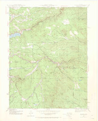
1942 Map of Tungsten
USGS Topo · Published 1969About this map
Roosevelt National Forest dominates this 1942 survey, revealing a landscape defined by mining history and early mountain ranching. The extraction of rare metals is central to the area's identity, evidenced by the Kakionga Mine and Manchester Mine, alongside the namesake settlement of Tungsten. These operations are interspersed with family-held lands such as Bradley Ranch, Giggey Ranch, and Skate Ranch, showing a pattern of high-altitude settlement where timber, minerals, and grazing intersected.
Find a feature on this map
49 named features on this map. Tap any name to fly to it.
Don’t see what you’re looking for? This feature index may not catch every label — zoom into the map to look around manually.
Map Details
Editions of this 1942 Tungsten Map
5 editions found

Other maps of this area

1899 · West Denver
USGS Topo · 1:125,000

1902 · Boulder
USGS Topo · 1:62,500

1904 · Boulder
USGS Topo · 1:62,500

1905 · Central City
USGS Topo · 1:62,500

1906 · Blackhawk
USGS Topo · 1:62,500

1910 · Central City
USGS Topo · 1:62,500

1912 · Central City
USGS Topo · 1:62,500

1915 · Longs Peak
USGS Topo · 1:125,000

1919 · Rocky Mountain National Park
USGS Topo · 1:125,000

1942 · Eldorado Springs
USGS Topo · 1:24,000