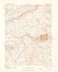
1942 Map of Tungsten
USGS Topo · Published 1963About this map
The Denver and Salt Lake railroad winds through the steep terrain of the Roosevelt National Forest, following the narrow corridors of South Boulder Creek during this 1942 survey. The area is defined by a deep history of extraction and water management, anchored by the Barker Reservoir near Nederland and the Dry Lake District to the north. These industrial footprints contrast with the scattered settlement of the front range, where small ranching outposts like Winiger Ranch and Giggey Ranch are connected by rugged tracks and the occasional mountain schoolhouse like Pine Glade Sch.
Find a feature on this map
56 named features on this map. Tap any name to fly to it.
Don’t see what you’re looking for? This feature index may not catch every label — zoom into the map to look around manually.
Map Details
Editions of this 1942 Tungsten Map
5 editions found

Other maps of this area

1899 · West Denver
USGS Topo · 1:125,000

1902 · Boulder
USGS Topo · 1:62,500

1904 · Boulder
USGS Topo · 1:62,500

1905 · Central City
USGS Topo · 1:62,500

1906 · Blackhawk
USGS Topo · 1:62,500

1910 · Central City
USGS Topo · 1:62,500

1912 · Central City
USGS Topo · 1:62,500

1915 · Longs Peak
USGS Topo · 1:125,000

1919 · Rocky Mountain National Park
USGS Topo · 1:125,000

1942 · Eldorado Springs
USGS Topo · 1:24,000