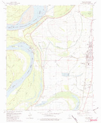
1981 Map of Tunica
USGS Topo · Published 1982About this map
The Mississippi River and its shifting alluvial landscape dominate this 1980s survey of northwestern Mississippi. The river's historical meanders are fossilized in oxbow lakes and complex point bars like Tunica Lake, Horse Head L, and Ship Island. The town of Tunica is the primary inland hub, served by the Illinois Central Gulf railroad and anchored by civic institutions like the County Hosp and the Technical Institute of Learning. To the south, the settlement of Austin sits near the banks of Lost Lake, highlighting the precarious relationship between Delta communities and the water. The landscape is dotted with numerous country churches and cemeteries, such as St Pauls Ch and Crystal Springs Cem, reflecting a rural social structure tied to the land. Drainage canals and bayous, including McKinney Bayou and White Oak Bayou, illustrate the extensive engineering required to maintain the agricultural productivity of the surrounding bottomlands.
Find a feature on this map
51 named features on this map. Tap any name to fly to it.
Don’t see what you’re looking for? This feature index may not catch every label — zoom into the map to look around manually.
Map Details
Editions of this 1981 Tunica Map
2 editions found
Other maps of this area

1908 · Dundee
USGS Topo · 1:24,000

1908 · Hollywood
USGS Topo · 1:24,000

1908 · Walnut Lake
USGS Topo · 1:24,000

1910 · Dundee
USGS Topo · 1:31,680

1910 · Walnut Lake
USGS Topo · 1:31,680

1913 · Hollywood
USGS Topo · 1:31,680

1931 · Horseshoe Lake
USGS Topo · 1:62,500

1939 · Clayton
USGS Topo · 1:62,500

1939 · Horseshoe Lake
USGS Topo · 1:62,500

1939 · Park Place
USGS Topo · 1:62,500