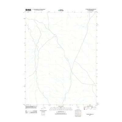
2011 Map of Tunnel Spring
USGS Topo · Published 2011About this map
Tunnel Spring and the surrounding high desert of Pershing County define this remote corner of Nevada as it appeared in the early 21st century. The landscape is characterized by intermittent drainages and critical water points that historically sustained livestock and early travel through the arid basin. Notable among these are Upper Stonehouse Spring and Lower Stonehouse Spring, which serve as vital landmarks in an otherwise stark terrain. The topographic detail follows the winding course of Sage Hen Wash as it carves through the north-south trending valleys. This survey is particularly useful for understanding the distribution of natural water sources in a region where such features dictated the placement of early ranching infrastructure and camps.
Find a feature on this map
4 named features on this map. Tap any name to fly to it.
Don’t see what you’re looking for? This feature index may not catch every label — zoom into the map to look around manually.
Map Details
Editions of this 2011 Tunnel Spring Map
This is the sole edition of this map. No revisions or reprints were ever made.
Other maps of this area

1886 · Granite Range
USGS Topo · 1:250,000

1894 · Granite Range
USGS Topo · 1:250,000

1955 · Lovelock
USGS Topo · 1:250,000

1959 · Lovelock
USGS Topo · 1:250,000
1964 · Tohakum Peak NE
USGS Topo · 1:24,000
1964 · Tohakum Peak SE
USGS Topo · 1:24,000

1964 · Kumiva Peak
USGS Topo · 1:62,500
1981 · Tunnel Spring
USGS Topo · 1:24,000
1981 · Sage Hen Spring
USGS Topo · 1:24,000
1981 · Bluewing Spring
USGS Topo · 1:24,000