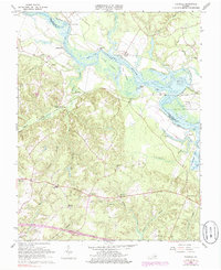
1966 Map of Tunstall
USGS Topo · Published 1985About this map
The Pamunkey River winds through this coastal plain landscape, defining the northern border of New Kent County and providing a historic corridor for the Pamunkey Indian Reservation. The geography is characterized by an intricate network of waterways and wetlands, including St Peters Swamp and Dickerson Swamp, which alternate with cultivated lands and small settlements. Along the river, tidal flats and bars like Gregory Bar reveal the influence of the Atlantic's tides reaching deep into the Virginia interior.
Find a feature on this map
59 named features on this map. Tap any name to fly to it.
Don’t see what you’re looking for? This feature index may not catch every label — zoom into the map to look around manually.
Map Details
Editions of this 1966 Tunstall Map
4 editions found
Other maps of this area

1917 · Toano
USGS Topo · 1:62,500

1918 · Charles City
USGS Topo · 1:62,500

1918 · Toano
USGS Topo · 1:62,500

1919 · New Kent
USGS Topo · 1:62,500

1920 · King William
USGS Topo · 1:62,500

1943 · Richmond
USGS Topo · 1:250,000
1949 · King William
USGS Topo · 1:24,000
1949 · Quinton
USGS Topo · 1:24,000
1949 · King And Queen
USGS Topo · 1:24,000

1949 · Tunstall
USGS Topo · 1:24,000