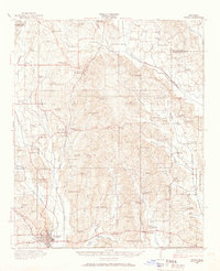
1921 Map of Tupelo
USGS Topo · Published 1966About this map
Tupelo serves as the hub of this early 1920s survey, where the Mobile and Ohio and St Louis San Francisco railroads intersect. This transit network anchors a landscape of small farming communities and educational outposts such as Blair, Saltillo, and Mooreville. The survey reveals a dense distribution of rural infrastructure, from cotton processing at Kirks Gin to the public County Farm, alongside numerous family-named landmarks like Parkers Store and Clayton Store.
Find a feature on this map
87 named features on this map. Tap any name to fly to it.
Don’t see what you’re looking for? This feature index may not catch every label — zoom into the map to look around manually.
Map Details
Editions of this 1921 Tupelo Map
2 editions found
Other maps of this area

1921 · Booneville
USGS Topo · 1:48,000

1921 · Tupelo
USGS Topo · 1:48,000

1922 · Booneville
USGS Topo · 1:62,500

1923 · Tupelo
USGS Topo · 1:62,500

1955 · Ripley
USGS Topo · 1:62,500

1955 · Sherman
USGS Topo · 1:62,500

1956 · Tupelo
USGS Topo · 1:250,000

1958 · Tupelo
USGS Topo · 1:250,000

1965 · Mooreville
USGS Topo · 1:24,000

1965 · Fulton
USGS Topo · 1:24,000