
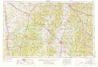
1956 Map of Tupelo
USGS Topo · Published 1967About this map
The Tupelo National Battlefield and Brices Cross Roads National Battlefield Site anchor this survey of northeast Mississippi, marking significant Civil War grounds amidst a mid-century landscape of expanding reservoirs and timberlands. Massive hydrological projects like Sardis Lake and Enid Lake define the western reaches, while the northeast is shaped by Pickwick Lake on the Tennessee River.
Find a feature on this map
172 named features on this map. Tap any name to fly to it.
Don’t see what you’re looking for? This feature index may not catch every label — zoom into the map to look around manually.
Map Details
Editions of this 1956 Tupelo Map
2 editions found
Other maps of this area

1905 · Waynesboro
USGS Topo · 1:125,000

1911 · Iuka
USGS Topo · 1:48,000

1914 · Iuka
USGS Topo · 1:62,500

1916 · Memphis
USGS Topo · 1:62,500

1921 · Booneville
USGS Topo · 1:48,000

1921 · Tupelo
USGS Topo · 1:48,000

1922 · Booneville
USGS Topo · 1:62,500

1923 · Tupelo
USGS Topo · 1:62,500

1924 · Gravelly Springs
USGS Topo · 1:48,000

1925 · Memphis
USGS Topo · 1:48,000