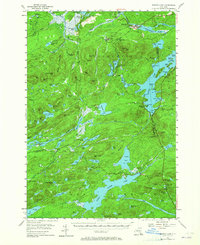
1954 Map of Tupper Lake
USGS Topo · Published 1965About this map
Piercefield and the lumbering community of Conifer anchor this mid-century survey of the northern Adirondacks, where industrial and recreational landscapes intersect along the New York Central Railroad. The rail line connects isolated stops such as Childwold Sta, Mt Arab Sta, and Sabattis, serving as the primary artery through the densely forested terrain of Adirondack State Park. To the east, the Raquette River feeds into Piercefield Flow and Raquette Pond, controlled by infrastructure like the Setting Pole Dam.
Find a feature on this map
122 named features on this map. Tap any name to fly to it.
Don’t see what you’re looking for? This feature index may not catch every label — zoom into the map to look around manually.
Map Details
Editions of this 1954 Tupper Lake Map
4 editions found


Other maps of this area

1903 · Big Moose
USGS Topo · 1:62,500

1903 · Raquette Lake
USGS Topo · 1:62,500

1903 · Blue Mountain
USGS Topo · 1:62,500

1904 · Long Lake
USGS Topo · 1:62,500

1905 · Saint Regis
USGS Topo · 1:62,500

1907 · Tupper Lake
USGS Topo · 1:62,500

1919 · Cranberry Lake
USGS Topo · 1:62,500

1920 · Childwold
USGS Topo · 1:62,500

1921 · Cranberry Lake
USGS Topo · 1:62,500

1921 · Childwold
USGS Topo · 1:48,000