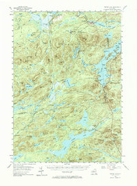
1954 Map of Tupper Lake
USGS Topo · Published 1973About this map
Piercefield and the lumber-rich landscapes of the Adirondack State Park are captured here just as post-war industry began to shift. The New York Central railroad serves as the primary artery for the region, connecting isolated settlements like Conifer, Childwold Sta, and Sabattis to the broader rail network. The map reveals the intricate water systems of the Raquette River basin, where Raquette Pond and Eagle Crag Lake are surrounded by significant topographical features such as Mt Arab and Wheeler Mtn.
Find a feature on this map
118 named features on this map. Tap any name to fly to it.
Don’t see what you’re looking for? This feature index may not catch every label — zoom into the map to look around manually.
Map Details
Editions of this 1954 Tupper Lake Map
4 editions found


Other maps of this area

1903 · Big Moose
USGS Topo · 1:62,500

1903 · Raquette Lake
USGS Topo · 1:62,500

1903 · Blue Mountain
USGS Topo · 1:62,500

1904 · Long Lake
USGS Topo · 1:62,500

1905 · Saint Regis
USGS Topo · 1:62,500

1907 · Tupper Lake
USGS Topo · 1:62,500

1919 · Cranberry Lake
USGS Topo · 1:62,500

1920 · Childwold
USGS Topo · 1:62,500

1921 · Cranberry Lake
USGS Topo · 1:62,500

1921 · Childwold
USGS Topo · 1:48,000