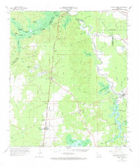
1967 Map of Turkey Creek
USGS Topo · Published 1969About this map
Lake Cocodrie and its intricate network of landings, including Blue Lake Landing and Clarks Landing, dominate the northwestern portion of this landscape. The Chicago Rock Island and Pacific Railroad cuts a straight north-south line through the center of the terrain, passing through the settlement of Turkey Creek and past the Meridian Lookout Tower. To the south, the timber-rich land transitions into the expansive Chicot State Park, where Chicot Lake and Mountain Bayou Lake are surrounded by numerous rural cemeteries and small churches like St James Ch and Little Union Ch.
Find a feature on this map
87 named features on this map. Tap any name to fly to it.
Don’t see what you’re looking for? This feature index may not catch every label — zoom into the map to look around manually.
Map Details
Editions of this 1967 Turkey Creek Map
This is the sole edition of this map. No revisions or reprints were ever made.
Other maps of this area

1935 · Beaver
USGS Topo · 1:31,680

1935 · Turkey Creek
USGS Topo · 1:62,500

1935 · Lecompte
USGS Topo · 1:62,500

1939 · Opelousas
USGS Topo · 1:62,500

1940 · Marksville
USGS Topo · 1:62,500

1942 · Oakdale
USGS Topo · 1:62,500

1947 · Ville Platte
USGS Topo · 1:31,680

1947 · Bond
USGS Topo · 1:31,680

1948 · Bunkie
USGS Topo · 1:62,500

1949 · Glenmora
USGS Topo · 1:31,680