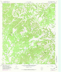
1964 Map of Turkey Knob
USGS Topo · Published 1982About this map
The hill country at the intersection of Bandera, Kerr, and Kendall counties is defined by a complex drainage network where Privilege Creek and Bear Creek carve through the high ground. This 1964 survey reveals a landscape of isolated rural institutions and family-named landmarks, most notably Rodriquez Ch and the Privilege Sch located near the southern county lines. The terrain is dominated by prominent elevations such as Turkey Knob and Cloud Mountain, while smaller drainage features like Bald Hollow and Cloud Hollow feed into the larger creek systems.
Find a feature on this map
30 named features on this map. Tap any name to fly to it.
Don’t see what you’re looking for? This feature index may not catch every label — zoom into the map to look around manually.
Map Details
Editions of this 1964 Turkey Knob Map
2 editions found
Other maps of this area

1954 · San Antonio
USGS Topo · 1:250,000

1956 · Comfort
USGS Topo · 1:62,500

1956 · Bandera
USGS Topo · 1:62,500

1956 · Medina Lake
USGS Topo · 1:62,500

1956 · Center Point
USGS Topo · 1:62,500

1957 · San Antonio
USGS Topo · 1:250,000

1964 · Comfort
USGS Topo · 1:24,000

1964 · Waring
USGS Topo · 1:24,000

1964 · Center Point
USGS Topo · 1:24,000

1964 · Bandera
USGS Topo · 1:24,000