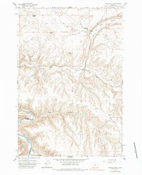
1964 Map of Turner Butte
USGS Topo · Published 1984About this map
The Oregon Trail winds across the high basalt plateaus of this 1964 survey, following an approximate route through a landscape defined by deep canyons and prominent volcanic buttes. To the west, the John Day River carves a sharp boundary between Sherman and Gilliam counties, while the Union Pacific railroad line mirrors the trail's path across Shutler Flat.
Find a feature on this map
27 named features on this map. Tap any name to fly to it.
Don’t see what you’re looking for? This feature index may not catch every label — zoom into the map to look around manually.
Map Details
Editions of this 1964 Turner Butte Map
2 editions found
Other maps of this area

1916 · Arlington
USGS Topo · 1:125,000

1916 · Condon
USGS Topo · 1:125,000

1953 · The Dalles
USGS Topo · 1:250,000

1956 · The Dalles
USGS Topo · 1:250,000

1957 · The Dalles
USGS Topo · 1:250,000

1964 · Turner Butte
USGS Topo · 1:24,000

1964 · Shutler Flat
USGS Topo · 1:24,000

1964 · Mc Donald
USGS Topo · 1:24,000

1970 · Devils Backbone
USGS Topo · 1:24,000
1970 · Mikkalo
USGS Topo · 1:24,000