
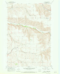
1967 Map of Turner
USGS Topo · Published 1971About this map
Tucannon River cuts a deep canyon through the rolling plateau of Columbia and Garfield Counties, anchoring a landscape defined by isolated rural settlements and steep drainages. In the late 1960s, the community of Turner served as a focal point along the Union Pacific rail line, accompanied by the nearby Turner Cem. The map documents the shifting footprint of local habitation, noting the Covello (Site) and its associated Covello Cem further south.
Find a feature on this map
22 named features on this map. Tap any name to fly to it.
Don’t see what you’re looking for? This feature index may not catch every label — zoom into the map to look around manually.
Map Details
Editions of this 1967 Turner Map
2 editions found
Other maps of this area

1937 · Pomeroy
USGS Topo · 1:96,000

1942 · Pomeroy
USGS Topo · 1:125,000

1950 · Penawawa
USGS Topo · 1:62,500

1950 · Hay
USGS Topo · 1:62,500

1952 · Hay
USGS Topo · 1:62,500

1955 · Pullman
USGS Topo · 1:250,000

1958 · Pullman
USGS Topo · 1:250,000

1967 · Hopkins Ridge
USGS Topo · 1:24,000

1967 · Cahill Mtn
USGS Topo · 1:24,000
1967 · Dayton
USGS Topo · 1:24,000