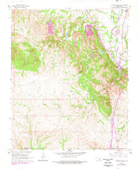
1964 Map of Turner Falls
USGS Topo · Published 1978About this map
The Arbuckle Mountains dominate this landscape, where the geological uplift creates the dramatic vertical drops of Turner Falls and Bridal Veil Falls. Located along the boundary of Murray Co and Carter Co, the area is a center for mid-century recreation and natural study, anchored by Turner Falls Park and Camp Classen. The map reveals a specialized landscape where leisure and industry coexist; the northern reaches transition from the limestone Quarries and the Southeast Hoover Oil Field to the residential and service clusters at Jollyville and Cedar Village. Transportation and commerce are centered near the Washita River and the Jolly Aero Airport, providing a clear record of the region's development before later highway expansions altered the local topography.
Find a feature on this map
25 named features on this map. Tap any name to fly to it.
Don’t see what you’re looking for? This feature index may not catch every label — zoom into the map to look around manually.
Map Details
Editions of this 1964 Turner Falls Map
2 editions found
Other maps of this area

1898 · Pauls Valley
USGS Topo · 1:125,000

1901 · Ardmore
USGS Topo · 1:125,000

1902 · Pauls Valley
USGS Topo · 1:125,000

1918 · Ardmore
USGS Topo · 1:125,000

1957 · Ardmore
USGS Topo · 1:250,000

1963 · Ardmore
USGS Topo · 1:250,000
1964 · Gene Autry
USGS Topo · 1:24,000

1964 · Springer
USGS Topo · 1:24,000

1964 · Turner Falls
USGS Topo · 1:24,000

1965 · Davis
USGS Topo · 1:24,000