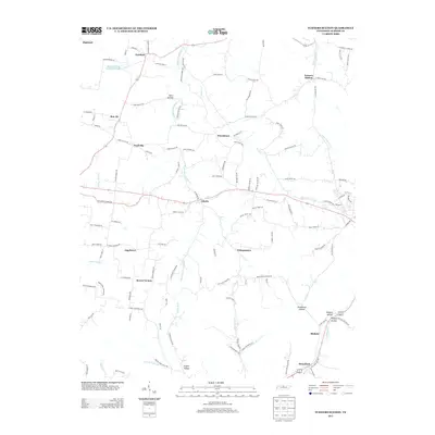
2013 Map of Turners Station
USGS Topo · Published 2013About this map
Turners Station and the surrounding rural communities of Sumner County are depicted here in detail during the early 21st century. The landscape is defined by a dense network of creek valleys and hollows, including Middle Fork Drakes Cr and the waters of Meadowbrook Game Farm Lake. These topographic features shaped the early settlement patterns of the region, where numerous small hamlets like Fairfield, Pondville, and Providence developed along the winding ridge roads and valley floors. In the southern portion of the map, the settlements of Bledsoe and Bransford sit near the headwaters of Bledsoe Cr. The map preserves a high concentration of family-named roads, such as Charles Brown Rd and Bishop Troutt Rd, which offer significant value for genealogists tracing ancestral landholdings in this part of Tennessee. The transition from the Highland terrain down into the various forks of the Caney and Drakes creeks illustrates the enduring rural character of the area.
Find a feature on this map
118 named features on this map. Tap any name to fly to it.
Don’t see what you’re looking for? This feature index may not catch every label — zoom into the map to look around manually.
Map Details
Editions of this 2013 Turners Station Map
This is the sole edition of this map. No revisions or reprints were ever made.
Other maps of this area

1928 · Adolphus
USGS Topo · 1:48,000

1931 · Lafayette
USGS Topo · 1:62,500

1931 · Adolphus
USGS Topo · 1:62,500

1942 · Gallatin
USGS Topo · 1:100,000

1954 · Petroleum
USGS Topo · 1:24,000
1954 · Hickory Flat
USGS Topo · 1:24,000

1954 · Adolphus
USGS Topo · 1:24,000

1955 · Bethpage
USGS Topo · 1:24,000

1955 · Gallatin
USGS Topo · 1:24,000

1956 · Nashville
USGS Topo · 1:250,000