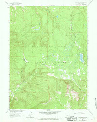
1961 Map of Turpin Reservoir
USGS Topo · Published 1969About this map
The Medicine Bow National Forest dominates this 1960s topographic landscape, defined by a complex network of drainage basins and high-altitude parks. Central to the area is the Turpin Reservoir, which captures the flow of Turpin Creek before it joins North Brush Creek to the south. The terrain is marked by distinct meadows or "parks," including Cecil Park and Fish Creek Park, which provide clearings amidst the timbered slopes. Evidence of mineral exploration appears at the Golden Gate Prospect in the southwest corner of the sheet. Transportation is limited to a singular Jeep Trail winding through the northern sections, reflecting the remote nature of this Carbon County backcountry. The map provides a detailed view of the headwaters for several major streams, such as East Fork Pass Creek and Mullison Creek, illustrating the hydraulic importance of this forest land.
Find a feature on this map
16 named features on this map. Tap any name to fly to it.
Don’t see what you’re looking for? This feature index may not catch every label — zoom into the map to look around manually.
Map Details
Editions of this 1961 Turpin Reservoir Map
4 editions found
Other maps of this area

1893 · Fort Steele
USGS Topo · 1:125,000

1906 · Medicine Bow
USGS Topo · 1:125,000

1908 · Medicine Bow
USGS Topo · 1:125,000

1939 · Saratoga
USGS Topo · 1:125,000

1954 · Rawlins
USGS Topo · 1:250,000

1955 · Elk Mountain SW
USGS Topo · 1:24,000

1955 · Coad Mountain
USGS Topo · 1:24,000

1958 · Rawlins
USGS Topo · 1:250,000

1958 · White Rock Canyon
USGS Topo · 1:24,000

1961 · Ryan Park
USGS Topo · 1:24,000