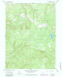
1961 Map of Turpin Reservoir
USGS Topo · Published 1984About this map
Medicine Bow National Forest encompasses this high-altitude landscape of the Snowy Range, where timbered ridges and open mountain parks define the terrain. The central feature is Turpin Reservoir, which feeds into Turpin Creek as it winds through the eastern portion of the quadrangle. This area serves as a primary drainage basin for several major waterways, including Pass Creek and North Brush Creek.
Find a feature on this map
14 named features on this map. Tap any name to fly to it.
Don’t see what you’re looking for? This feature index may not catch every label — zoom into the map to look around manually.
Map Details
Editions of this 1961 Turpin Reservoir Map
4 editions found
Other maps of this area

1893 · Fort Steele
USGS Topo · 1:125,000

1906 · Medicine Bow
USGS Topo · 1:125,000

1908 · Medicine Bow
USGS Topo · 1:125,000

1939 · Saratoga
USGS Topo · 1:125,000

1954 · Rawlins
USGS Topo · 1:250,000

1955 · Elk Mountain SW
USGS Topo · 1:24,000

1955 · Coad Mountain
USGS Topo · 1:24,000

1958 · Rawlins
USGS Topo · 1:250,000

1958 · White Rock Canyon
USGS Topo · 1:24,000

1961 · Ryan Park
USGS Topo · 1:24,000