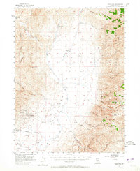
1956 Map of Tuscarora
USGS Topo · Published 1965About this map
Tuscarora sits at the center of this 1950s study, revealing the mining foundations of the Independence Valley. The townsite is surrounded by notable silver and gold mining operations including the Commonwealth Mine, Queen Mine, Navajo Mine, and Grand Prize Mine, along with several prospects. This cluster of claims at the foot of Cottonwood Peak illustrates the intense industrial activity that once dominated this high-desert landscape. Beyond the town, the map documents large-scale ranching operations like the Spanish Ranch and Quarter Circle S Ranch, which utilize the drainages of the South Fork Owyhee River. The terrain transitions from the valley floor to the high elevations of the Humboldt National Forest in the east, where Jacks Peak and Wheeler Mountain overlook a network of canyons, including Smith Canyon and Jerritt Canyon. Evidence of early 20th-century aviation is also present with a Landing Strip located just east of the main settlement.
Find a feature on this map
48 named features on this map. Tap any name to fly to it.
Don’t see what you’re looking for? This feature index may not catch every label — zoom into the map to look around manually.
Map Details
Editions of this 1956 Tuscarora Map
3 editions found
Other maps of this area

1955 · McDermitt
USGS Topo · 1:250,000

1955 · Wells
USGS Topo · 1:250,000

1956 · Tuscarora
USGS Topo · 1:62,500

1956 · Mt. Blitzen
USGS Topo · 1:62,500

1956 · Bull Run
USGS Topo · 1:62,500

1956 · Wild Horse
USGS Topo · 1:62,500

1958 · Wells
USGS Topo · 1:250,000

1959 · McDermitt
USGS Topo · 1:250,000

1961 · Wells
USGS Topo · 1:250,000

1964 · Wilson Reservoir
USGS Topo · 1:62,500