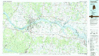
1986 Map of Tuscumbia
USGS Topo · Published 1986About this map
The Tennessee River corridor dominates this mid-1980s portrait of Northern Alabama, where a series of massive impoundments—Pickwick Lake, Wilson Lake, and Wheeler Lake—define the regional geography and economy. The industrial and population core known as the Shoals is fully detailed, centering on Florence, Sheffield, Muscle Shoals, and Tuscumbia. This landscape is marked by a complex interplay of infrastructure and conservation, where the heavy freight lines of the Southern railroad and the historic Natchez Trace Parkway pass near extensive protected grounds like the Sevenmile Island Wildlife Management Area. To the south, the terrain rises from the river valley toward Little Mountain, giving way to the agricultural expanse of Moulton Valley. Smaller settlements such as Tharp Town, Leighton, and Courtland provide important touchpoints for local family history and rural development patterns.
Find a feature on this map
58 named features on this map. Tap any name to fly to it.
Don’t see what you’re looking for? This feature index may not catch every label — zoom into the map to look around manually.
Map Details
Editions of this 1986 Tuscumbia Map
3 editions found
Other maps of this area

1888 · Cullman
USGS Topo · 1:125,000

1888 · Huntsville
USGS Topo · 1:125,000

1892 · Cullman
USGS Topo · 1:125,000

1892 · Huntsville
USGS Topo · 1:125,000

1905 · Waynesboro
USGS Topo · 1:125,000

1911 · Iuka
USGS Topo · 1:48,000

1914 · Iuka
USGS Topo · 1:62,500

1914 · Rogersville
USGS Topo · 1:48,000

1914 · Muscle Shoals
USGS Topo · 1:48,000

1916 · Muscle Shoals
USGS Topo · 1:62,500