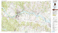
1986 Map of Tuscumbia
USGS Topo · Published 1992About this map
The Tennessee River serves as the central artery for this mid-1980s landscape, connecting a chain of significant reservoirs including Pickwick Lake, Wilson Lake, and Wheeler Lake. The quadrangle captures the industrial and urban core of the Shoals region, where Tuscumbia, Sheffield, Muscle Shoals, and Florence converge at the river's edge. This area, historically defined by the rocky obstructions of the river, is shown here as a modern navigational and power-generating hub, with the Southern railroad line and the Natchez Trace Parkway providing critical transportation links across the northern Alabama counties.
Find a feature on this map
142 named features on this map. Tap any name to fly to it.
Don’t see what you’re looking for? This feature index may not catch every label — zoom into the map to look around manually.
Map Details
Editions of this 1986 Tuscumbia Map
3 editions found
Other maps of this area

1888 · Cullman
USGS Topo · 1:125,000

1888 · Huntsville
USGS Topo · 1:125,000

1892 · Cullman
USGS Topo · 1:125,000

1892 · Huntsville
USGS Topo · 1:125,000

1905 · Waynesboro
USGS Topo · 1:125,000

1911 · Iuka
USGS Topo · 1:48,000

1914 · Iuka
USGS Topo · 1:62,500

1914 · Rogersville
USGS Topo · 1:48,000

1914 · Muscle Shoals
USGS Topo · 1:48,000

1916 · Muscle Shoals
USGS Topo · 1:62,500