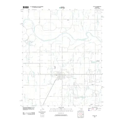
2009 Map of Tuttle
USGS Topo · Published 2009About this map
The settlement of Tuttle serves as the focal point of this 2009 landscape, situated south of the meandering Canadian River. This period shows the community's residential expansion and organized street grid, which is bounded by several creeks that drain the surrounding prairie. To the north, the Riverside Cemetery overlooks the river valley, while a network of rural roads such as S 104th St and S Richland Rd connect the town to outlying agricultural plots.
Find a feature on this map
51 named features on this map. Tap any name to fly to it.
Don’t see what you’re looking for? This feature index may not catch every label — zoom into the map to look around manually.
Map Details
Editions of this 2009 Tuttle Map
This is the sole edition of this map. No revisions or reprints were ever made.
Other maps of this area

1893 · Oklahoma City
USGS Topo · 1:62,500

1893 · Minco
USGS Topo · 1:62,500

1904 · Chickasha
USGS Topo · 1:125,000

1954 · Oklahoma City
USGS Topo · 1:250,000

1956 · Oklahoma City
USGS Topo · 1:62,500

1957 · Oklahoma City
USGS Topo · 1:250,000

1963 · Oklahoma City
USGS Topo · 1:250,000
1965 · Blanchard
USGS Topo · 1:24,000
1965 · Oklahoma City SW
USGS Topo · 1:24,000
1966 · Minco NE
USGS Topo · 1:24,000