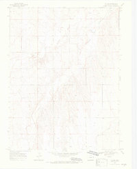
1969 Map of Tuttle
USGS Topo · Published 1972About this map
Tuttle sits on the high plains of Eastern Colorado in the late 1960s, a landscape defined by the drainage of the South Fork Republican River. The terrain is etched by seasonal watercourses like Spring Creek and Dry Gulch, which cut through the tableland to feed the river. This survey, grounded in 1968 aerial photography and 1969 field checks, reveals a sparse ranching and agricultural environment where infrastructure is limited to primitive roads, a scattering of Well sites, and a Gravel Pit. The map captures the precise surveyor's lines of Township 6, 7, and 8 South, including fine red dashed lines indicating property-defining fence lines across the open range. It is an exacting record of the Kit Carson County backcountry before modern center-pivot irrigation and contemporary land-use patterns further altered the prairie surface.
Find a feature on this map
9 named features on this map. Tap any name to fly to it.
Don’t see what you’re looking for? This feature index may not catch every label — zoom into the map to look around manually.
Map Details
Editions of this 1969 Tuttle Map
4 editions found
Other maps of this area

1954 · Limon
USGS Topo · 1:250,000

1957 · Limon
USGS Topo · 1:250,000

1958 · Limon
USGS Topo · 1:250,000

1969 · Settlement
USGS Topo · 1:24,000

1969 · Tuttle
USGS Topo · 1:24,000

1969 · Bethune
USGS Topo · 1:24,000

1969 · Idalia SW
USGS Topo · 1:24,000

1969 · Kirk
USGS Topo · 1:24,000

1969 · Stratton
USGS Topo · 1:24,000
1978 · Joes SW
USGS Topo · 1:24,000