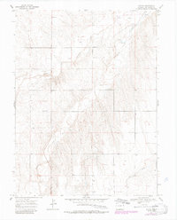
1969 Map of Tuttle
USGS Topo · Published 1985About this map
South Fork Republican River defines the drainage pattern of this high plains landscape in eastern Kit Carson County. The small settlement of Tuttle occupies the northeast corner of the sheet, serving as a focal point in a territory largely characterized by rolling topography and intermittent watercourses. Low-lying areas are marked by Spring Creek and the meandering path of Dry Gulch, which cut through the terrain toward the river valley. Sparse industrial activity is evidenced by a Gravel Pit located near the river's bend, while numerous points labeled Well indicate the critical importance of groundwater for ranching or agricultural survival in this semi-arid region. These 1980s updates, based on earlier aerial photography, show the slow evolution of rural infrastructure and land use across the Colorado plains.
Find a feature on this map
7 named features on this map. Tap any name to fly to it.
Don’t see what you’re looking for? This feature index may not catch every label — zoom into the map to look around manually.
Map Details
Editions of this 1969 Tuttle Map
4 editions found
Other maps of this area

1954 · Limon
USGS Topo · 1:250,000

1957 · Limon
USGS Topo · 1:250,000

1958 · Limon
USGS Topo · 1:250,000

1969 · Settlement
USGS Topo · 1:24,000

1969 · Tuttle
USGS Topo · 1:24,000

1969 · Bethune
USGS Topo · 1:24,000

1969 · Idalia SW
USGS Topo · 1:24,000

1969 · Kirk
USGS Topo · 1:24,000

1969 · Stratton
USGS Topo · 1:24,000
1978 · Joes SW
USGS Topo · 1:24,000