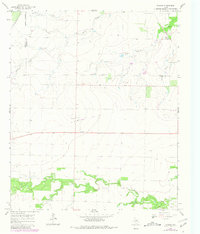
1965 Map of Tuxedo
USGS Topo · Published 1981About this map
Tuxedo and the surrounding rolling plains of Jones County are captured here in the mid-1960s, reflecting a landscape defined by ranching, petroleum extraction, and fading rail infrastructure. The small settlement of Tuxedo serves as a local hub, anchored by the Tuxedo Ch and situated along an Old Railroad Grade that once connected these rural outposts to larger markets. To the south, Fairview Ch stands near the banks of California Creek, a significant watercourse that meanders across the lower portion of the map along with Skinout Creek. Oil exploration is evident throughout the area, with numerous Oil Wells peppered across the ranch lands, particularly near Cecil. In the northeastern corner, Paint Creek flows past Flat Top Ranch and the Capron Cem, providing a detailed look at the family-named landmarks and small-scale infrastructure that supported this Texas community during the postwar era.
Find a feature on this map
20 named features on this map. Tap any name to fly to it.
Don’t see what you’re looking for? This feature index may not catch every label — zoom into the map to look around manually.
Map Details
Editions of this 1965 Tuxedo Map
2 editions found

Other maps of this area

1891 · Anson
USGS Topo · 1:125,000

1893 · Roby
USGS Topo · 1:125,000

1893 · Anson
USGS Topo · 1:125,000

1931 · Aspermont
USGS Topo · 1:62,500

1954 · Lubbock
USGS Topo · 1:250,000

1954 · Big Spring
USGS Topo · 1:250,000

1954 · Abilene
USGS Topo · 1:250,000

1954 · Wichita Falls
USGS Topo · 1:250,000

1958 · Big Spring
USGS Topo · 1:250,000

1958 · Wichita Falls
USGS Topo · 1:250,000