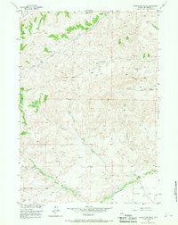
1956 Map of Twentyone Creek
USGS Topo · Published 1967About this map
Dickie Ranch and Rhodes Ranch anchor this mid-century look at the ranching landscape of Hot Springs County. The drainage network of Twentyone Creek, including its West Fork and East Fork, carves through the terrain alongside Little Grass Creek and Wagonhound Creek. The map documents the vital infrastructure of the high plains, showing a web of Jeep Trails connecting remote outposts such as Cow Camp and Rankin Cow Camp. To the south, Cottonwood Creek flows past Putney Flat, while several Gas Wells indicate the early industrial activity in the region. This survey, part of the Missouri River Basin development program, provides a detailed record of water sources including various unnamed Springs and a small Lake essential for livestock in this semi-arid environment.
Find a feature on this map
19 named features on this map. Tap any name to fly to it.
Don’t see what you’re looking for? This feature index may not catch every label — zoom into the map to look around manually.
Map Details
Editions of this 1956 Twentyone Creek Map
2 editions found
Other maps of this area

1913 · Grass Creek Basin
USGS Topo · 1:62,500

1915 · Grass Creek Basin
USGS Topo · 1:62,500

1955 · Thermopolis
USGS Topo · 1:250,000

1956 · Milk Creek
USGS Topo · 1:24,000

1956 · Twentyone Creek
USGS Topo · 1:24,000

1956 · Soapy Dale Peak
USGS Topo · 1:24,000

1956 · Adam Weiss Peak
USGS Topo · 1:24,000

1958 · Thermopolis
USGS Topo · 1:250,000

1962 · Thermopolis
USGS Topo · 1:250,000
1965 · Embar
USGS Topo · 1:24,000