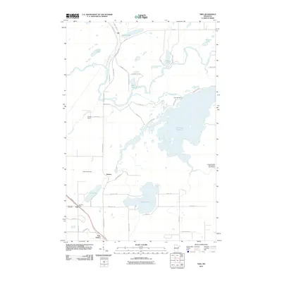
2010 Map of Twig
USGS Topo · Published 2010About this map
Fish Lake Reservoir dominates the eastern landscape of this 2010 survey, illustrating a region defined by extensive water management and small residential clusters. To the north, the settlement of Taft sits near Bergen Lake, while the southern corridor is anchored by the community of Twig. This area shows a transition from the industrial and transportation-focused zones near Twig Station and Sheltons Airport to the recreational and conservation-minded surroundings of Caribou Lake and the Canosia Wildlife Management Area 78 Dam. The map documents the local infrastructure of Grand Lake Township, including the Twig Post Office and Grand Lake Cemetery, connected by a network of rural roads such as Munger Shaw Rd and Taft Rd. The Cloquet River and Us-Kab-Wan-Ka River carve through the northern woods, highlighting the importance of the river systems to the local geography.
Find a feature on this map
52 named features on this map. Tap any name to fly to it.
Don’t see what you’re looking for? This feature index may not catch every label — zoom into the map to look around manually.
Map Details
Editions of this 2010 Twig Map
This is the sole edition of this map. No revisions or reprints were ever made.
Other maps of this area

1895 · Duluth
USGS Topo · 1:62,500

1953 · Twig
USGS Topo · 1:24,000

1953 · Canyon
USGS Topo · 1:24,000

1953 · Shaw
USGS Topo · 1:24,000

1953 · Saginaw
USGS Topo · 1:24,000

1953 · Adolph
USGS Topo · 1:24,000

1953 · Duluth Heights
USGS Topo · 1:24,000

1953 · Boulder Lake Reservoir
USGS Topo · 1:24,000

1953 · Fredenberg
USGS Topo · 1:24,000

1953 · Independence
USGS Topo · 1:24,000