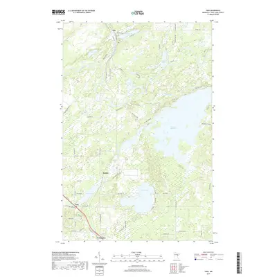
2019 Map of Twig
USGS Topo · Published 2019About this map
Twig and its namesake Twig Station anchor the southwestern corner of this survey, illustrating the local importance of transportation corridors in Saint Louis County. The landscape is defined by an intricate network of waterways, including the expansive Fish Lake Reservoir and the winding Cloquet River, which drain through the timbered wetlands. Small settlements like Bartlett and Taft are connected by a mix of modern county highways and local routes such as Munger Shaw Rd. For those researching local roots, the Grand Lake Cem provides a specific point of interest. A notable legacy of past industry is the Old Railroad Grade in the west, which serves as a terrestrial record of the region's logging or transit history. Numerous smaller lakes, such as Caribou Lake and Side Lake, dot the quadrangle, reflecting the classic post-glacial geography of Northern Minnesota.
Find a feature on this map
69 named features on this map. Tap any name to fly to it.
Don’t see what you’re looking for? This feature index may not catch every label — zoom into the map to look around manually.
Map Details
Editions of this 2019 Twig Map
This is the sole edition of this map. No revisions or reprints were ever made.
Other maps of this area

1895 · Duluth
USGS Topo · 1:62,500

1953 · Twig
USGS Topo · 1:24,000

1953 · Canyon
USGS Topo · 1:24,000

1953 · Shaw
USGS Topo · 1:24,000

1953 · Saginaw
USGS Topo · 1:24,000

1953 · Adolph
USGS Topo · 1:24,000

1953 · Duluth Heights
USGS Topo · 1:24,000

1953 · Boulder Lake Reservoir
USGS Topo · 1:24,000

1953 · Fredenberg
USGS Topo · 1:24,000

1953 · Independence
USGS Topo · 1:24,000