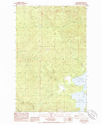
1985 Map of Twin Lakes
USGS Topo · Published 1985About this map
North Twin Lake and South Twin Lake dominate the eastern edge of this landscape within the Colville Indian Reservation. This mid-1980s survey captures a high-elevation environment defined by steep drainages and prominent peaks like Lynx Mountain and Bitterroot Mtn. The hydrological network is well-defined, with Beaver Dam Creek, Granite Creek, and Lynx Creek carving through the terrain to feed the larger lake system. Near the lakeshore, the Rocky Point Campground indicates the area's use for recreation, while the Oregon City Ridge looms to the west. Localized industry is present in the form of a Borrow Pit near Boss Creek, while the surveyor also noted Johns Creek at the northern margin. The map provides a clear record of the road network and water bodies before further modern development, preserving the 1980s footprint of this part of Ferry County.
Find a feature on this map
16 named features on this map. Tap any name to fly to it.
Don’t see what you’re looking for? This feature index may not catch every label — zoom into the map to look around manually.
Map Details
Editions of this 1985 Twin Lakes Map
2 editions found
Other maps of this area

1948 · Wilmont Creek
USGS Topo · 1:62,500

1950 · Wilmont Creek
USGS Topo · 1:62,500

1952 · Keller
USGS Topo · 1:62,500

1952 · Twin Lakes
USGS Topo · 1:62,500

1953 · Seventeenmile Mtn.
USGS Topo · 1:62,500

1954 · Okanogan
USGS Topo · 1:250,000

1956 · Wilmont Creek
USGS Topo · 1:62,500

1958 · Okanogan
USGS Topo · 1:250,000

1984 · Nespelem
USGS Topo · 1:100,000
1985 · Moon Mountain
USGS Topo · 1:24,000